

When you first arrive at Gullfoss (translated as the “Golden Falls”), you’ll wonder what all the fuss is about. You approach from the top, down river from where the falls drop off, and as you draw nearer, it looks like a small, albeit pretty, waterfall. You’ll probably think it seems a bit disappointing to be the most famous waterfall in Iceland, but then as you walk closer, you’ll suddenly realize that the falling water just… disappears. That is, until you step closer still and the ground abruptly opens in front of you, leaving you peering down at a thunderous rush of water and a very steep, very narrow, very startling drop.
Gullfoss waterfall is on the Hvítá river, and is part of the famous Golden Circle – a popular daytrip from Reykjavik that includes Þingvellir National Park and Geysir. As the furthest point from Reykjavik, it’s usually the final stop people make while touring the area, and it leaves a lasting impression.
The Gullfoss first drops over a wide cascade, weaving around and over chunks of black rock, before shifting to the opposite direction and falling a further 32 metres into a narrow canyon. While the drop is impressive, it’s the force of so much water being squeezed into such a thin ravine that gives the Golden Falls their awesome power. The rush of water is deafening, and when the sun is right, rainbows appear in the mist over the falls.
A pathway leads down to a rocky outcrop at the base of the first cascade, where visitors can get so close they could lean over and dip their fingers into the water if they so wished (not recommended!). The path is steep and slippery and the falls are hypnotizing as they gush past. A slim piece of rope is all that acts as a handrail down the path along Gullfoss waterfall, not offering much comfort in the way of protection. The viewing area is always filled with a mix of people – those daring themselves to stand on the edge of the Gullfoss, and those pressed up against the rocky walls of the canyon, too scared to move.
Amazingly, the beauty of the Golden Falls was almost destroyed in the 1920s, when the Icelandic government partnered with a private developer and planned to turn the waterfall into a hydroelectric power plant. The landowner, Tomas Tomasson, refused to sell, despite the offers he had received from numerous developers who had lusted over the falls for years. In 1907, one Englishman offered 50 times what Tomasson’s farmhouse was worth, to which Tomasson famously replied, “I won’t sell my friend.”
When the government ignored Tomasson and stepped in with their own plans for Gullfoss waterfall, Tomasson’s daughter Sigridur set out on a pilgrimage to save her father’s land. She walked all the way to Reykjavik, where she threatened to throw herself over the falls if the development went through. Despite her threat, the government refused to back down, until, in 1928, the developer failed to pay the rental fee and the project fell through. In 1975, the land was donated to the Icelandic Nature Conservation Council. Since then, Gullfoss has been preserved as a national park.
When to go to Gullfoss Waterfall
The best time to visit Gullfoss is from May to August as Iceland’s weather is at its warmest, the days are at their longest, and all tourist accommodations are up and running. Of course, it also means it’s when the country is at its busiest. If you prefer less crowds, but still want the convenience of mild weather and long days, visit in late April or early September. Just be warned that many hotels and restaurants in the smaller towns only operate during peak tourist season.
For those willing to brave the cold weather, Gullfoss waterfall is stunning in the winter, when sections of the falls turn to ice crystals, and the entire area is blanketed in snow. Of course, that also means the path to the falls (slippery even in summer) is exceptionally treacherous and requires extra caution.
Gullfoss makes up part of the Golden Circle – an area that includes Þingvellir National Park and Geysir, and is a popular daytrip from Reykjavik. Give yourself a full day to take in all that the Golden Circle has to offer.
Odds n’ ends
- There is no entrance fee to see Gullfoss, so your only costs will be hiring a car rental or tour group to take you. The entire Golden Circle is an easy and scenic drive from Reykjavik.
- The path to the Golden Falls is steep and slippery – especially if there is a strong mist – and the only thing between you and the falls is a thin piece of rope to hold onto. Tread carefully.
Want a guide?
Go Travel Iceland
Offers a variety of tours, including a Golden Circle daytrip.
Reykjavik Excursions
Trips are available for those wishing to go directly to Gullfoss, or to visit all of the Golden Circle.
Iceland Encounter
Offers private, customized adventure tours. Visits to the Golden Circle can be done on their own as a one-day trip, or in combination with a longer tour package stretching over several days.
Places to eat
Gullfoss Cafe
A small café located in the visitor centre above the falls, rumoured to serve fantastic lamb soup.
Places to Stay
Hotel Gullfoss
A small, no-frills hotel located midway between Geysir and Gullfoss.
Hotel Odinsve
This boutique hotel in downtown Reykjavik has crisp, clean rooms and super friendly staff.
Luna Apartments
For more privacy, these fully furnished apartments owned by Hotel Odinsve (above) offer a quiet home away from home. Apartments are only available for guests staying three or more days.
Home Apartments
These fully furnished apartments are both cozy and uber stylish and are located in downtown Reykjavik, in the heart of the city’s nightlife and shopping district.
101 Hotel
For the ultimate splurge, this designer boutique hotel is uber chic and trendy.
This article originally appeared on thecircumference.org.
Featured image: Wikimedia Commons
If you’re prone to carsickness, a trip to Australia’s Jenolan Caves may not be for you. The road leading into the Jenolan Caves is a winding, up, down, narrow jumble of twists and turns that can leave even the calmest passenger feeling a bit nauseated. Travelling into the valley with just a sliver of pavement to follow and a sudden drop on my left side, I wasn’t sure whether to hide my head in the backseat or press my face to the window so I could take in the gorgeous view of the Blue Mountains region below me.
The Jenolan Caves are a mere three hours from Sydney, but they feel a million miles away. Heading inland, away from the breezy coast and into the heavy heat of the interior, passing along the gorgeous bush of the Blue Mountains, it’s easy to feel like you’re venturing into uncharted territory; well, that is if you ignore the scads of tourists and vacationing Sydneysiders that the area attracts during peak season.
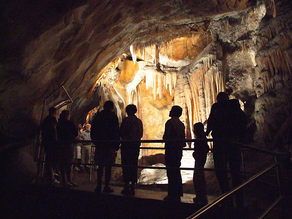
New South Wales’ Jenolan Caves are the most famous limestone caves in Australia, and are made up of an intricate web of narrow passageways, underground rivers, natural arches, and dramatic stalactites and stalagmites. Walking through them feels like you’re venturing deep within the earth and back in time, which in a way, you are.
While the Jenolan Caves had been known to the Aboriginals for thousands of years (as “Binoomea,” meaning “Dark Places”), it wasn’t until the mid-1800s that formal exploration began by European settlers, under government control. Since then, dozens of caves have been uncovered, but much of the area remains unexplored and it’s unknown how many other caves may exist within the system. The Jenolan Caves are considered to be incredibly old; a 2006 study published in the Australian Journal of Earth Sciences showed that the caves date back 340 million years – making them the oldest cave system in the world.
Human impact on the caves is a constant concern, and for that reason, many caves have limits on how many people can visit per day, month, or even per year. The Mammoth Cave has a maximum of 10 people per month, and the Naked Lady Chamber allows only 16 people per year to pass through.
There are 11 “show caves” including the Orient Cave, Temple of Baal, Pool of Cerberus, Imperial Cave and Lucas Cave, all of which have fairly easy walking paths, staircases, handrails and electric lighting. For the more adventurous there is adventure caving. These Jenolan Cave tours will have you crawling and squeezing your way through narrow, undeveloped caves with only a headlamp to light your way.
When to go to Jenolan Caves
The best time to take a Jenolan Cave tour is during the spring and fall, although visiting at any time of year is possible. The summer can bring oppressive heat and the nearby town of Katoomba has been known to get snow in winter, so climate-wise, April/May and September/October are your best bets. (For you northern hemisphere folks, remember that summer and winter months are reversed when down under.)
During holidays, Jenolan and the Blue Mountains are a popular family daytrip from Sydney and Canberra. If you want to avoid the crowds, go while school’s still in.
For the month of May, Jenolan hosts an annual Underworld Annual History Festival, when “dead” characters return to life and lead touists on historical walking tours through the caves.
Odds n’ ends
- There are no fuel stations at Jenolan. When travelling from Sydney, the last service station is at Mount Victoria or Lithgow. When travelling from Bathurst or Canberra, the last service station is at Oberon or Bathurst.
- The narrow road into the Jenolan valley becomes one-way between 11:45 am to 1:15 pm to allow coaches to enter the property. Visitors wishing to leave the caves during that time can take Oberon Road.
- Because the area is so popular, and because some caves have restrictions on visitors, it’s best to book in advance. Either arrive and book your tours early in the morning before the best caves are claimed, or, if there’s a rare cave you’re eager to see, check ahead that it’s available and book it well before you arrive.
- You can also time your trip to coincide with a Jenolan Cave concert. On select Saturday’s in the Cathedral Chamber you can enjoy the sounds of classical music resounding off the caverns walls.
This article originally appeared on thecircumference.org.
Featured image: Wikimedia Commons

The seaside temple of Pura Tanah Lot is probably the most famous and most photographed place in Bali. Every hotel offers sunset tours out to the temple, and every visitor has seen photos of it before they’ve even visited. There’s really only one reason for its iconic status: it’s beautiful.
Of course, such a popular tourist attraction is bound to fall victim to commercialization, and at Tanah Lot, a flea market of vendors and warung (food stalls) greets you as soon as you enter the property. It’s a bit jarring at first to hear the calls of salespeople and to see the swarms of tourists, especially when you consider that Pura Tanah Lot is one of the most sacred Hindu temples in the country. But don’t let the chaos deter you. A trip to Bali isn’t complete without seeing this famous site firsthand.
The Tanah Lot temple sits on a rock a few metres away from land, and when the tide is in, it becomes its own island, with steps that look like they disappear deep into the sea. But when the tide recedes, visitors can walk across the ocean floor to the base of the temple (but not inside – the temple is only open to practicing Balinese Hindus).
At the base of Tanah Lot, visitors can enter a small cave with a sacred spring and receive a traditional good will blessing, done with a sprinkle of water and a dab of rice to the forehead. At dusk, when the sky turns shades of pink and orange and casts rays of light that look too pretty to be real, you can see why a Tanah Lot sunset is the most photographed scene in Bali.
Sadly, much of the structure had to be rebuilt, after thousands of years of erosion and earthquakes had all but destroyed the temple and the rock it sits on. Today, approximately one-third of the rock is artificial. Some might see this as a disappointment, but it would have been more of a disappointment if nothing had been done and the erosion had washed it out to sea.
History of the Tanah Lot temple places it as being built sometime around the 16th century. The story says that a saint named Dang Hyang Dwi Jendra, who had dedicated his life to spreading Hinduism, was the creator of the temple. It’s believed he settled in the village of Beraban, near the current site of Tanah Lot, and began to preach.
Nearby, he found a large rock along the coast, in the shape of a bird, and chose that as his spot for meditation. The villagers embraced Dang Hyang Dwi Jendra’s teachings, and, by abandoning their prior beliefs, they angered the village’s priest, Bendesa Beraban Sakti, who tried to run the new man out of the village.
When confronted, Dang Hyang Dwi Jendra responded by pushing his meditative rock out into the sea. He created sea snakes from his scarf to guard the new island; it’s still said that those snakes live in caves underneath the temple, guarding the god of the sea.
The island was named “Tengah Lot,” meaning “land in the minds of the sea.”
When to go to Tanah Lot
The best time to visit Pura Tanah Lot in Bali is during the dry season from April to September. While the temperature stays warm year-round, it can get quite humid during the wet season. Note that peak tourist season generally runs from July to early September, as well as from late December to mid-January. Prices are usually much higher at these times of year, and accommodations book up fast. For cheap flights to Bali, you may wish to avoid the peak seasons.
An annual arts festival, featuring traditional Balinese dancers, is held at the temple in late May.
Odds n’ ends
- The entrance fee to Tanah Lot temple is 10,000 rupiah (approximately $1 USD) for foreigners, as well as between 2,000 and 10,000 rupiah for parking (depending on whether you’re arriving by motorcycle, car, or bus).
- Remember that Tanah Lot is first and foremost a religious temple. While visitors won’t necessarily need to wear a sarong or sash (unlike at other temples), they should still dress and act in a way appropriate to a religious site.
Places to eat
Tanah Lot Restaurants
There are four restaurants on the property; all are open from 8 am to 7 pm, and serve a mix of Indonesian, Chinese, and European foods. The parking lot is also lined with warung stalls for quick eats.
Bumbu Bali
Okay, so it’s not exactly close to Tanah Lot, but this restaurant in Nusa Dua is a must-eat. Offering delicious Indonesian dishes in a romantic on-the-beach setting, it’s considered one of the best restaurants in Bali. It’s pricier than your average Balinese meal, but still very affordable – especially considering the quality. A great place to splurge.
This article originally appeared on thecircumference.org.
Featured image: Wikimedia Commons
To skate the Rideau Canal is to conquer the fierce February winds, and then succumb to the inevitable muscle aches that sear your legs in the days that follow.
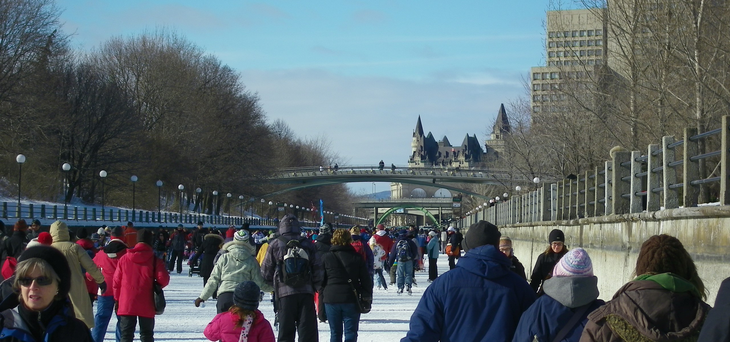
Stretching out at just less then 16 km round-trip (the size of more than 100 hockey rinks laid end-to-end), Ottawa’s Rideau Canal is the world’s largest skating rink. Starting at the base of the copper-peaked Parliament buildings and Chateau Laurier hotel, it then winds through downtown Ottawa, weaving under bridges, alongside parks, and past neighbourhoods of heritage homes, before finally ending at the historic Hartwell Locks. At the Locks, a sign proudly proclaims that skaters have achieved 7.8 km; now they just have to skate all the way back.
Originally built in 1832 as a supply route between Montreal and Kingston, today the Rideau is the oldest functioning canal in North America. In the summer months, the Rideau Canal is in full operation, with many of the locks still relying on old-fashioned muscle power to guide boats through.
In 2007, it was designated as a UNESCO World Heritage Site, recognized for its design, construction, and role in Canadian history. Yet, it is in the winter with the commencement of Rideau Canal skating, that it really comes to life when transformed into the world’s most famous ice rink.
The crowd throngs when you start skating the Rideau Canal, and the ice is rough and difficult to manoeuvre. But a few metres in, after the crowd thins out and the Parliament buildings recede into the distance, the ice turns silky smooth, which is the result of nightly flooding and constant maintenance by the National Capital Commission.
Along the way, every kilometre or so, pine trees, picnic tables and fire pits pop up like oases, offering rest and shelter from the burn in your legs and wind on your face. Food kiosks resembling log cabins serve apple cider and hot chocolate, hot dogs and poutine. But by far the most popular food item is the beaver tail—a fried dough pastry smothered in your choice of cinnamon, maple butter, chocolate, or garlic and cheese. The smell of deep-fried dough permeates the length of the Canal.
Once rested and fed, continue onwards, beneath bridges and archways and past the artists selling paintings of Canadian winters. Further on, you will reach Dow’s Lake, where the narrow Canal opens up into a windswept tundra of ice and snow, before tucking back into the shelter of trees and working its way towards the locks.
Despite the length of the Canal, the end comes abruptly, and though your legs are tired, it’s sad to see the final marker indicating the end. Time to loop around it, and skate back!
When to Go Rideau Canal Skating
The best time to skate the Rideau Canal is in January and February, when the weather is at its coldest and the Canal is fully frozen.
During the first three weekends in February, Ottawa hosts the annual Winterlude Festival, with ice sculptures, snow carving contests, outdoor dance parties, and prix-fixe (fixed price) menus at local restaurants. But remember, the second Monday in February is a Family Day holiday in Ontario, which means Ottawa and the Canal are extremely crowded for that entire weekend. The extra people creates a lively atmosphere, especially when you throw in all the Winterlude activities, but be prepared for booked-up hotels, long line-ups at cafes and restaurants, and lots of children whipping past you on the Canal.
Odds n’ Ends
- Wear lots of layers. Ottawa can be very cold and windy, but you may get quite warm as you’re skating.
- Remember that the Rideau Canal is 8 km long one-way, and however far you go, you’ll have to skate back just as far. Bring a backpack with boots to change into so that you can take off your skates if you get too tired.
- Bring money with you; skating on the Canal is free, but the rink is lined with treat stands offering hot chocolate, apple cider, beaver tail pastries, maple taffy, and other Canadian winter goodies that will tempt you along the way.
- Check the ice conditions before you go. The city of Ottawa monitors the conditions daily, as do most hotels. Remember that the Canal is not a man-made rink, and as such, the skating season and ice conditions can change from year-to-year, or even day-to-day, depending on the weather.
- Hockey sticks are not permitted on the Canal.
Places to Eat
Le Moulin de Provence
Bustling French bakery in historic Byward Market, offering homemade breads, decadent pastries, and fresh salads. Perhaps most famous for its “Obama cookies” (shortbread in the shape of a maple leaf), named in honour of a 2009 visit and cookie purchase by the U.S. president.
The Grand Pizzeria and Bar
Offering authentic, award-winning Napoletana pizza, paninis, and homemade pastas.
Places to Stay
Chateau Laurier
One of Canada’s most famous hotels, located at the head of the Rideau Canal and overlooking the Parliament Buildings, the Ottawa River, and Byward Market.
This article originally appeared on thecircumference.org.
